Local News
Rollback of Wetlands Protections undermines Chesapeake Bay Cleanup
The non-partisan, environmental watchdog group that alerted the public to dangerous levels of E Coli contamination in the Shenandoah River in 2017 has released a critical appraisal of new Trump Administration roll back of one aspect of Chesapeake Bay watershed protections.
The Town of Front Royal’s work in recent years on improving its wastewater treatment facility and processes was mandated in part by the Shenandoah River Basin being included in the Chesapeake Bay Watershed impacted by regulatory protections at federal and state levels. In addition to helping clean up local waterways, the end result of those regulations is protection of the Chesapeake Bay and its billion dollar annual fishing industry.
So, while yesterday’s release doesn’t involve wetlands in the Shenandoah Valley, we are connected in the end result of negative impacts on regulatory protections of the Chesapeake Bay and consequent negative impacts on the seafood we, the nation, and likely a good bit of the world, eat from it.

Environmental Integrity Project Executive Director Eric Schaeffer – Courtesy Photos EIS-Tom Pelton-Ari Phillips-US Fish & Wildlife Service
On Thursday, September 12, Environmental Integrity Project Executive Director Eric Schaeffer issued the following statement regarding the Trump Administration’s new “Waters of the U.S. Rule,” which was finalized Thursday, September 12:
“This regulatory rollback by the Trump Administration is a clear setback for the Chesapeake Bay cleanup because it threatens to strip federal protections from some wetlands in our region that provide important water pollution filtration services. Specifically, the change could eliminate federal protections from 34,560 acres of scattered wetlands called ‘Delmarva Potholes’ on the Eastern Shore that help reduce the runoff of farm fertilizer into the Bay.”
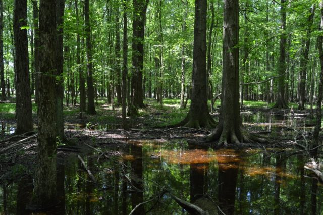
‘Delmarva Pothole’ wetlands play a filtration role for the Bay in providing a habitat for amphibians, birds, and other wildlife that help stem farm runoff pollution from the Chesapeake Bay and tributaries feeding it. Pictured are wetlands near Damsontown Rd. in Ruthsburg, Md.
The press release continues to explain and map out the so-called “Delmarva Pothole” wetlands and their role in providing watershed protections to the Chesapeake Bay.
“A December 2018 report by the Environmental Integrity Project, titled ‘Undermining Protections for Wetlands and Streams’ mapped the location of these Chesapeake wetlands at risk in the Trump Administration rollback. Although seldom discussed, 4,950 “Delmarva Potholes” wetlands cover 34,560 acres of Eastern Shore farmland in Maryland and Virginia. That acreage is the equivalent of 54 square miles of wetlands – a landmass almost the size of Washington, D.C. – that provide important habitat for amphibians, birds, and other wildlife and perform filtration services to keep farm runoff pollution out of the Chesapeake Bay.
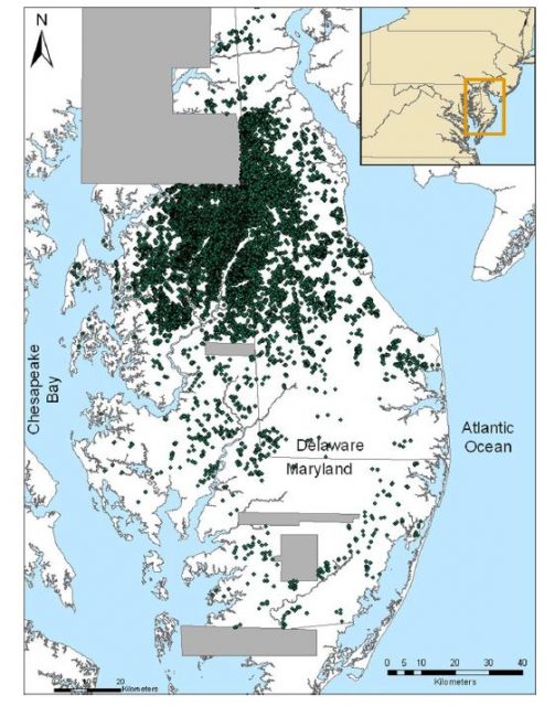
Map showing the Delmarva Peninsula, in Maryland and Delaware, including individual Delmarva Bays that were identified using lasers from airplanes (Light Detection and Ranging or LiDAR imagery). Gray areas represent zones where LiDAR data were not available. From “Distribution, Morphometry, and Land Use of Delmarva Bays,” by D. E. Fenstermacher and colleagues published in the journal Wetlands on October 8, 2014.
“Delmarva Potholes are non-tidal wetlands in low-lying areas that are not usually connected on the surface to rivers or streams. Their waters often connect beneath the ground, or through ditches, to nearby streams and waterways, especially in rainy seasons. In appearance and formation, Delmarva potholes are often oval-shaped depressions carved out by the wind in past centuries. Historically, 119,000 acres of these ‘Delmarva potholes’ existed on the Delmarva Peninsula. But over the last three centuries, farmers drained more than two thirds of them to convert them to cropland. The remaining patches of Delmarva pothole wetlands — an endangered species, of sorts — are now usually wooded patches with wet soil surrounded by acres of corn and soybean fields.”
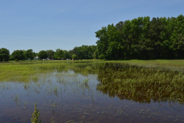
‘Delmarva Pothole’ wetland border development off Camp Road, south of Denton, Md.
Schaeffer is a former Director of Civil Enforcement at the U.S. Environmental Protection Agency.
For more information on EPA’s action today, visit EPA’s “Waters of the US” webpage here: https://www.epa.gov/newsreleases/epa-us-army-repeal-2015-rule-defining-waters-united-states-ending-regulatory-patchwork
For a copy of EIP’s analysis of the impact of the rollback on the Chesapeake Bay region, visit: https://www.environmentalintegrity.org/news/report-details-impact-on-the-chesapeake-bay-of-trumps-proposed-rollback-of-wetlands-regulations/
(The Environmental Integrity Project is a nonprofit, nonpartisan organization based in Washington, D.C., and Austin, Texas, that protects public health and the environment by investigating polluters, holding them accountable under the law, and strengthening public policy.)

Spanberger Emphasizes Job Growth, Business Investment After New Jobs Report

House Panel Challenges Defense Official on Iran Military Strategy

Maryland Delegation in Congress Backs Effort to Regulate Energy Use by AI Companies

Virginia’s Congressional Map Is the Fairest in America – Democrats Want to Make It the Worst.

Art, Poetry and Big Questions Take Center Stage at Laurel Ridge Humanities Week

Virginia Pushes New Protections for Pregnant and Postpartum Women Behind Bars

Should High Schools Have Career Coaches? Virginia Lawmakers Say Not Yet

‘World Is Watching’: Climate Advocates Focus on Data Center Energy Use

Industrial Zoning Among Key Focal Points at Town Planning Commission Work Session

General Assembly Nixes Bills That Required Data Centers to Get SCC Certificate

After Past Vetoes, Bias Training Bill for Medical Licenses Could Become Law

Virginia Joins Multistate Lawsuit Challenging Trump Administration Over New Global Tariffs

Kristi Noem Out As DHS Secretary; Trump to Nominate Oklahoma Senator Mullin

Five Tips to Make Spring Cleaning More Enjoyable

New ‘No Tax on Car Loan Interest’ Break Could Save Drivers Hundreds

Cline Launches Statewide Campaign to Oppose Redistricting Referendum

Obama, Spanberger Welcome Virginia Supreme Court of Virginia Ruling Allowing Redistricting Vote

Warren County School Board Reviews Health Insurance Options Amid Steep Cost Increase

Warren County School Board Ends ESS Substitute Contract

Cars Changing Lives Plans May 8 Golf Tournament to Support Transportation for Families in Need

William Gladwell Mason “Bill” Wilson (1936 – 2026)

Early Voting Begins Friday for Virginia Redistricting Referendum

Immigration Arrests Spark Bills to Guarantee K-12 Education Rights for All Virginia Students

Last-Minute Tweak to Bill Could Double Virginia’s Medical Malpractice Payment Caps for Plaintiffs
