Opinion
Shenandoah’s natural transportation highway
Before commerce was first introduced to the railroad phenomena and before the macadamized turnpike stretched from Winchester to Harrisonburg, our great valley had a natural transportation highway. It would take a number of enterprising partnerships, strategic planning and long term labor intensive efforts to deliver the physical improvements necessary to access a narrow, twisting and shallow river.
In colonial times travel by land was done by old-fashioned stagecoach, on horseback, or on foot. The roads were in a habitually deplorable condition. Many of the towns were thoroughly without roads, only connected with their neighboring towns by Indian trails. Great quantities of hemp, grain and other farm products were often brought to town from the remote settlements on pack horses.
Wagon transport was not an essential factor in Shenandoah Valley trade until the 1760s, when the shipping requirements of the hemp industry provided the first major demand for wagon teams. A warehouse for hemp was established in Frederick County and freight wagons necessary to conduct trade first became a priority.
Wagons in general were expensive to construct and demand for wheelwrights and other skilled craftsmen were greater than the supply. The local and legendary Newtown wagons had not yet been developed to haul hemp and farm produce from the river valleys and mountain slopes over the Blue Ridge to busy city warehouses. Overland transportation using wagons was always an option, but costly and dependent on good weather. Wagon routes were often a treacherous option due to heavy spring and summer rains.
Beginning in 1790, the Shenandoah Valley produced a surplus of flour for export and the developing requirement for passage to eastern markets in Alexandria, Richmond and Fredericksburg grew more intense. Farmers searched for other avenues of conveyance and the solution appeared to be in a natural, but potentially unnavigable transportation highway. Written records reflect that in the 1790s, pig iron and flour were first loaded onto primitive rafts in the North River at what would become Bridgewater and sent down the Shenandoah during high water seasons.

Historical Society Museum – Bridgewater, VA located on the banks of the North River, has been a center of commerce for over 175 years. Its history began with a quiet little settlement previously known as Magill’s Ford, Dinkletown and Bridgeport. Photos / Nancy Gunderman
Around that time George Washington became actively involved in efforts to establish an organization whose objective was to develop water routes between the Potomac and Shenandoah rivers employing a series of canals and locks. Washington led the way in chartering the Potomac Company by first seeking interstate cooperation between Virginia and Maryland in developing the Potomac River. Both states passed legislation in early 1785.
Washington had also called for the establishment of a U.S. Armory at Harpers Ferry, located at the mouth of the Shenandoah River. By 1799, as work commenced on the armory, improvement of the Shenandoah River was a requirement to channel up-river lumber and iron into Harpers Ferry as material resources to support site construction and later for forging muskets, rifles and pistols.
The Virginia legislature unsuccessfully attempted to establish an independent company for developing the Shenandoah River to handle substantial boat navigation. In 1803 it granted a charter to the Potomac Company. In 1805, after obtaining the necessary start-up loans, the company hired a boat crew to inspect the Shenandoah from Harpers Ferry to Port Republic on the South Fork. The Potomac Company concentrated efforts toward managing the most difficult river rapids by building a series of canals and locks on the lower seven miles of navigation above Harpers Ferry. These milestones were completed in 1806.
Potomac Company crews continued to hammer away, black powder blasting rock and dredging the river bed and by 1807 established a navigable passage for trade between Harpers Ferry and Port Republic, then the head of navigation on the Shenandoah. In especially shallow areas, funnel-shaped wing dams made of stone were built with an opening in the center to form a higher flowing passageway for boat traffic.
Historical evidence accounts for an unsophisticated cargo carrying boat, called a Gundalow, to become a mainstay of valley commerce and transportation from roughly the turn of the nineteenth century until after the Civil War. These whitewater river crafts were heavy, with square bows and sterns, flat bottoms, pine hull/floor boards and measuring as much as 9 ½ feet wide by 76 to 90 feet long. The side planks were two inches thick and fourteen or more inches wide.
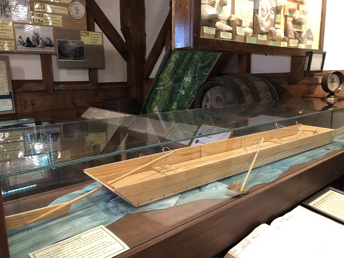
The yellow pine scale model of a wooden gundalow flat bottom river boat built by George Erdman is on display at the Shenandoah Valley Cultural Heritage Museum at the Edinburg Mill.
The Gundalow was a short-lived boat built for quick inexpensive shipment of bulk commodities (8-12 tons) down river. The boats were most often loaded with flour, lumber and pig iron. Other diverse items such as pork, beef, tobacco, ginseng, copper, manganese, wheat, whiskey, furs, tanned leather and occasionally herds of turkeys were pre-staged on site while boat captains waited for high waters in order to make the trip downriver to Harper’s Ferry or continue on the Potomac to Georgetown.
The crafts were mostly built by local sawmills near Port Republic. A gundalow was usually manned by six crew, four pole men and two oarsmen, one for each tiller. Boatmen manipulated the craft through manmade and natural chutes, rapids and constant choppy waters, docking at river stations to discharge or take on cargo. At their destinations, gundalows were disassembled and sold as inexpensive lumber to frugal builders who then used the recycled material for wall, ceiling and floor construction in houses.
Once landed and unloaded, the boatmen received good paying wages and returned to their point of departure on foot. Front Royal was often a popular place to rest on the return trip. A man could buy new clothes, or get a room, bath, meal, bottle and perhaps some female companionship here. These river sailors were both boisterous and unruly and locals claimed they carried a readily combustible powder keg in their hearts. Boatmen mingling with horse and cattle wranglers, wagon drivers and trainmen created an atmosphere for ferocious nightly saloon brawls giving the village of Riverton on the northern edge of Front Royal, the unflattering nickname of “Helltown.”
The Potomac Company was never able to generate enough funding to fully support navigation improvements to the upper stretches of the Shenandoah River. In 1816, the company sold its Shenandoah works and permissions to the New Shenandoah Company. The new company’s first objective was the physical improvement of the Shenandoah River between Port Republic and Harpers Ferry. Countless wing dams, cut through and tow paths had to be constructed, but by 1825, a continuous and improved waterway extended from Port Republic to the river’s confluence with the Potomac at Harpers Ferry.
By 1829, valley farmers believed that river transport was a cheap, safe and viable alternative to any wagon route east. Therefore, prior to valley rail and turnpike service, upland farmers and iron masters turned to the Shenandoah River whose waters were made navigable by the very spring thaws and ice melts that mired wagon routes and they did so with great zeal. Later channels were sufficiently cleared to navigate gundalows on the North River as far as Mt. Crawford and Bridgewater, on the South River at Grottoes and the Middle River, as far as Mt. Meridian.
Port Republic, founded in 1802 and located at the convergence of the North and South River, established an authentic harbor as docks lined the riverbanks in order to oblige increasing river traffic. The prospect of shipping and boat building propelling immense river trade slowly transformed the newly chartered town into a center for local commerce and agriculture. The nearby Massanutten Mountain ridge provided the tall, limbless long-leaf yellow pines that fueled boat building and other lumber dependent industries. Methodist and Presbyterian churches, mercantile stores, grist mills, leather tanneries, blacksmiths, saw mills, a tilt hammer shop as well as hat makers, shoe factories, wood workers, coopers and tailor shops eventually lined both Main and Water Streets.

Port Republic Museum – Port Republic, VA was founded in 1802 because land speculators were quick to recognize the vast industrial potential of the area, valuing the rivers as a source of power for driving machinery and as waterways for transporting articles of trade.
The New Shenandoah Company began upgrading the North Fork in 1825 for boats measuring a minimum of 66 feet long and 8 feet in width. Contractors not only cleared the river segments congested by trees and other debris, but also built works including dams and chutes. Records of the company indicate that the contract called for river navigation enhancements up to Tumbling Run, halfway between Strasburg and Toms Brook, but continued improvements were extended up to the dam at Pennybackers Mill, near New Market by May, 1832. This site was known as the head of navigation and may also have been a boat yard with docking capabilities for loading cargo similar to Port Republic, however on a much smaller scale. In 1845, accounts reflect that the North Fork was navigable at high water for large boats up to Plains Mill near Timberville.
The macadamized Valley Turnpike, completed in 1841, connected the western valley to the Winchester and Potomac Railroad and gradually reduced the gundalow traffic on the North Branch to almost non-existent status by 1850. The Manassas Gap Railroad arrived in Front Royal in 1854. Gundalows that once floated down the forks of the Shenandoah River to Harpers Ferry and beyond, now were unloading their cargo on to trains at Front Royal which transported them to market points east.
During the Civil War Valley Campaign in 1862, Stonewall Jackson swept the Valley burning bridges to slow Union troops, rendering wagon transport all but impossible. The destruction of bridges briefly revitalized gundalow traffic on the Shenandoah. After the war, gondolas continued to be used to move product to Front Royal until the bridges could be rebuilt and the Manassas Gap rail lines extended to Harrisonburg in 1868. The Shenandoah Valley Railroad connected the south fork communities with Hagerstown MD and Waynesboro, VA in 1881.
Some farmers, out of respect for southern tradition, continued to use this river system friendly to the “sons of the valley” as late as 1880. Despite sporadic business from loyal farmers, millers and timbermen; destructive winter weather, floods, railroads and modern turnpikes pushed the river captains, sailors and gundalows into the dust bin of history. Only recent scholarship has brought them all back to life again. Perhaps someone will soon uncover a nineteenth century gundalow buried under river silt somewhere in the Harpers Ferry basin?
Note: An outstanding source of information on the Shenandoah River is The Shenandoah River Atlas, prepared by W. E. Trout, III and Friends of the Shenandoah River.
Mark P. Gunderman
Stephens City, Virginia