Local News
You never know what historical documents you might find laying around a Circuit Court Clerk’s Office
When does a Circuit Court Clerk’s Office become a “museum”? That is the question that arose after a recent visit to the Warren County Circuit Court Clerk’s Office and the spotting of a framed, under glass map of Shenandoah National Park on the wall. A closer examination of text printed at the bottom indicated that the map of the full length of the park from Front Royal/Warren County in the north to the City of Waynesboro, Augusta and Albemarle Counties 105.5 miles to the south, dated to a 1927-28 Department of the Interior geological survey citing “tentative boundaries”.
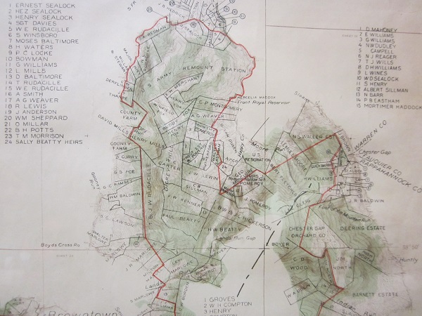
Further examination of the map revealed family names and plats of those families’ properties along the length of the map. Names surrounding a large swath of property cited as “U.S. Army Remount Station” on the northern end had names familiar to Warren County to this day, including: Sealock, Rudacille, Baltimore, Weaver, Millar, Mills, Derflinger, Merchant, Fox, Carter, Pomeroy, Tharpe, Hickerson, Eastham, Wines, and “the Sally Beatty heirs” (probably not Warren and Shirley yet), among others.
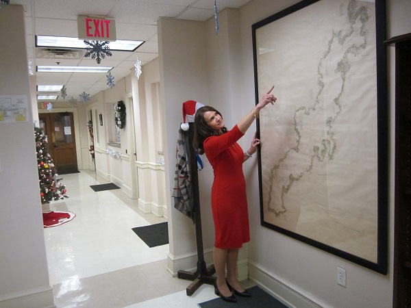
‘That’s us way up at the top’ Circuit Court Clerk Angie Moore points out as her office hallway maintains the holiday spirit. Below, tighter shots of that northern section, including Front Royal and Warren County with names of involved landowners and residents. Map Photos Courtesy Circuit Court Clerk’s Office, Royal Examiner Clerk’s office photos Roger Bianchini

WHOA!!! What we appeared to have in front of us was a historical record of the pending, circa the early 1930s displacement of as many as 2,000 people from an estimated 500 families stretching across eight Virginia Counties, including our own. (Displacement numbers source: “Virginia Living” online, “Time to Leave” by Katrina Powell). Knowing people from here with a number of those family names on one side or the other of their genealogies, we decided to track down Warren County Circuit Court Clerk Angie Moore to inquire about her new office wall hanging.
“Actually I was looking for another map ironically, and came across this. The Town had asked if there were any documents or maps directly related to the Byrd Act of 1932, which proposed putting local roads in the hands of the state for maintenance during the Great Depression, to relieve localities of such a financial burden. While I didn’t find what the Town was looking for, I did find this gem. I was pretty excited when I unrolled it, as it hadn’t been unrolled since 1932,” she noted of a markered date on the rolled up map. “So I was pretty happy about that,” Moore told us of her discovery made in August 2020.
“And it just so happened a couple weeks later Greg Brooks, a vendor with C.W. Warthen, came in to look at some of our conservation work to be sent off. I showed it to him and he was very excited because he works across the state and had never seen a full map from Warren County all the way down to the Albemarle area – the full park – and with the little individual plats for everybody (who owned property in the proposed national park area). He’s seen, of course, each area with their own section of the park but not of the park’s entirety. So, he was pretty thrilled about that as well, Moore began of her discovery process.
So, is what she stumbled across in the Warren County Circuit Court land record archives a one of a kind survivor of the process of creating Shenandoah National Park, we wondered. “All eight counties the Shenandoah National Park transverses should have one, they just may not realize it, as I literally stumbled upon this,” Moore reasoned, adding, “This is a draft map, used as an exhibit in the eminent domain case “The State Commission on Conservation and Development v. Virginia Atwood, and others, at Law 221”, which can be found in Deed Book 38. As a draft map, there were additions and deletions to what was actually acquired as a result of the condemnation/eminent domain case.
“I knew I wanted to share this map with Warren County and those who visit our courthouse. So, I asked Warthen vendor Greg Brooks while he was here a couple weeks after the map’s discovery if we could accomplish sharing this map by having it framed. He enthusiastically confirmed that could be done. I made the decision to have this beautiful map framed so others could enjoy it. It hangs in a central location of the clerk’s office and truly is a treasure.

The full proposed Shenandoah National Park map dated to a 1927-28 Department of the Interior geological survey citing ‘tentative boundaries’ with involved landowner parcels cited the length of park. Prior to its August 2020 discovery, this map was last publicly seen in a courtroom in 1932 condemnation, eminent domain cases locally.
“I have been told the Clerk of Madison County is a bit jealous of our find. She has been working on a preservation project on the park and has a map of Madison County, but not an overall map”. Has Moore invited her Madison County counterpart for a visit to see her discovery, we asked.
“I’ve invited her. She is welcome any time she wants to visit. And as I stated, she may have an overall map, but has not uncovered hers just yet”. This map has, after all, survived being housed elsewhere and moved to the current location in 1936 after the original brick courthouse, constructed in 1836 was torn down to make way for the current courthouse.
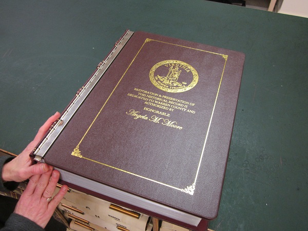
“The map was sent out for preservation and framing September 2020, with the volumes included in our most recently awarded grant from the Library of Virginia at the time. But due to supply issues with framing materials, we did not have the map returned to us until May 2022. Luckily, the volumes included in our $41,121.00 grant award did not take that long to be returned. I am excited to say we have quadrupled the amount of grant awards since my first year in office. I started with a $12,107 award in 2020, increased that to $41,121.00 in 2021, and will hopefully soon find out if our 2022 $40,819.75 grant was approved. Tracy Harter, Senior Local Records Archivist with the Library of Virginia, has been very helpful in our quest to conserve Warren County’s oldest records. Tracy travels the state visiting every courthouse to determine materials in the most vulnerable condition and makes recommendations for conservation and preservation.
Do we dare now call this court clerk’s office the Warren County Circuit Clerk’s Office and Historical Museum of the Creation of Shenandoah National Park, we asked.
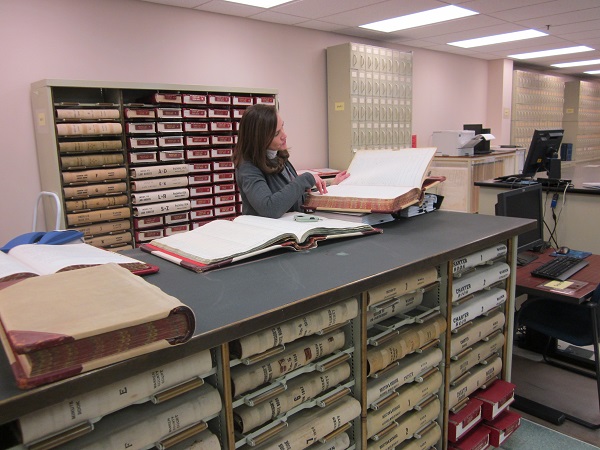
Circuit Court Clerk Moore examines records related to the creation of Shenandoah National Park.

“I am very proud of the efforts this office has taken to make land records more accessible through digitization and conservation in the past three years. I have managed to have all deed books, plats, and will books digitized. This is a huge benefit to those who most frequent the land record room, as land records are available through Secured Remote Access. This has cut down on overall foot traffic to the record room, which also helps in the conservation effort, as materials are not manually handled as often. My plan is to continue digitizing law books and chancery files in the future, as well as preserving additional Shenandoah National Park documents. Rockingham County Circuit Court Clerk Chaz Haywood, who we have discovered also has a full park map, has put me in contact with Dr. Kevin Borg and Dr. Kevin Hegg with James Madison University, who have created Histories along the Blue Ridge, which is accessible by visiting https://omeka.lib.jmu.edu. My hope is to include materials located in Warren’s record room to this site. It’s a lot of work I look forward to completing in the years to come”.
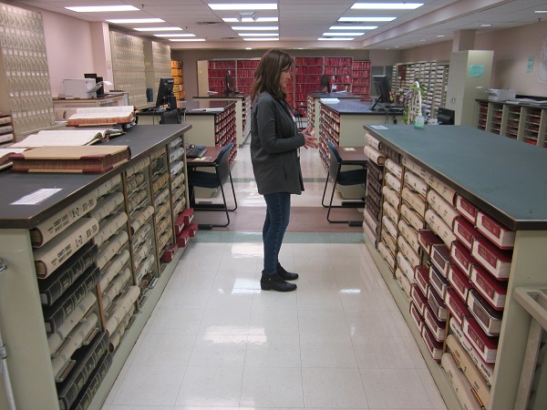
Moore ponders land and estate records housed in the clerk’s office, some of which have been authorized for preservation efforts and funding by the state, as well as digitization for ease of access to involved parties needing access to those records.


Virginia State Police Urge Sober Plans for Saint Patrick’s Day Celebrations

In a One-Party County, Internal Party Decisions Affect Us All

Virginia State Police Seize Nearly 100 Pounds of Narcotics, Recover Firearms in Weekly Crime Suppression Effort

Barton Charles “Bart” Haller (1940 – 2026)

Dawn Lee Dodson (1970 – 2026)

Mary Helen “Nanny” Spires Johnt (1954 – 2026)

Another Round of ‘Momnibus’ Bills Are Headed Towards the Governor This Year

Virginia Joins States Challenging Trump Admin Regulations That Limit Free Birth Control Access

Update: Charlotte Swanson Smith (1951 – 2025)
Why We are Challenging the Republican Mass Meeting

Bruce Norman Showman (1954 – 2026)

EDA Relaunches Small Business Loan Program to Help Warren County Entrepreneurs Access Capital

Targeted Exercises to Improve Your Putting

The Hidden Risks of House Hunting Solely Online

Choosing the Right Cleaner for Every Surface in Your Home

New Church Among Consent Items at County Planning Commission Meeting

Warren County GOP Mass Meeting Results Challenged After Allegations of Voting Irregularities

‘This Is About Equity’: In Richmond, Virginia Workers, Lawmakers Push for Inclusive Labor Rights for All

After Five Years of Attempts, Virginia On Track to Set Up a Prescription Drug Affordability Board

New Drug Take-Back Box at Warren County Sheriff’s Office Offers Safe Way to Dispose of Medications

‘Feeding Our Neighbors’ Continues Local Effort to Provide Free Meals in Front Royal

Blair David Eller (1963 – 2026)

Writing Workshop at Samuels Public Library Aims to Help Community Communicate More Clearly

Simple Steps to Reduce Wildfire Risk Around Your Home
