
Local News
National Weather Services issues a winter weather advisory
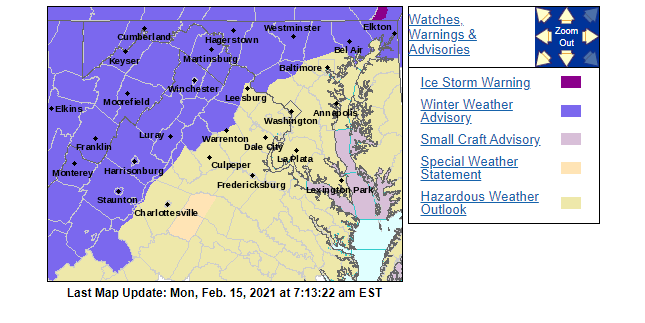
Winter weather advisory remains in effect until 7 am Tuesday
* WHAT…Light mixed precipitation today, with primarily freezing rain tonight. Little to no snow and sleet accumulation. Ice accumulations of one-tenth to one-quarter of an inch, the highest on the ridges.
* WHERE…Portions of western Maryland and eastern West Virginia, and Frederick County Virginia.
* WHEN…Until 7 AM EST Tuesday.

* IMPACTS…Difficult travel conditions and scattered tree damage are possible.
PRECAUTIONARY/PREPAREDNESS ACTIONS…
Slow down and use caution while traveling.
When venturing outside, watch your first few steps taken on
steps, sidewalks, and driveways, which could be icy and slippery,
increasing your risk of a fall and injury.

This Hazardous Weather Outlook is for portions of eastern West Virginia, northern and central Virginia, and central and western Maryland.
.DAY ONE…Today and Tonight
A Winter Weather Advisory is in effect through tonight for portions of western Maryland, eastern West Virginia, and Frederick County Virginia. Additional Winter Weather Advisories are in effect for the I-81 corridor and northern Maryland until 10 AM, then again from 5 PM until 7 AM.
.DAYS TWO THROUGH SEVEN…Tuesday through Sunday

There is an enhanced winter storm threat late Wednesday night into Friday morning. There is increased potential of more significant travel impacts and closures.
FORECAST
Washington’s Birthday
A chance of freezing rain before 10 am, then a chance of freezing rain and sleet between 10 am and 11 am, then rain likely after 11 am. Cloudy, with a high near 34. Calm wind becoming east around 5 mph in the afternoon. The chance of precipitation is 60%. Little or no ice accumulation expected. Little or no sleet accumulation expected.

Rain or freezing rain, becoming all rain after 11 pm. Patchy fog between 8 pm and 10 pm. Patchy freezing fog between 10 pm and 11 pm. Low around 32. East wind 5 to 7 mph becoming calm after midnight. The chance of precipitation is 100%. New ice accumulation of less than 0.1 of an inch possible.
A slight chance of freezing rain and sleet before 7 am, then a slight chance of sleet between 7 am and 8 am. Patchy fog before 8 am. Patchy freezing fog before 7 am. Otherwise, cloudy, then gradually becoming mostly sunny, with a high near 45. Light southwest wind becoming northwest 10 to 15 mph in the morning. Winds could gust as high as 23 mph. The chance of precipitation is 20%.
Partly cloudy, with a low around 20. Northwest wind 7 to 10 mph.
Partly sunny, with a high near 34. Northwest wind 5 to 8 mph becoming light and variable.

Snow, mainly after 1 am. Low around 25. The chance of precipitation is 80%.
Snow and freezing rain, possibly mixed with sleet before 2 pm, then freezing rain and sleet. High near 33. The chance of precipitation is 100%.
Freezing rain and sleet before 9 pm, then freezing rain between 9 pm and midnight, then rain after midnight. Low around 30. The chance of precipitation is 90%.
A chance of rain and snow before 11 am, then a chance of rain between 11 am and 5 pm, then a chance of rain and snow after 5 pm. Partly sunny, with a high near 40. The chance of precipitation is 40%.
A chance of snow before 7 pm. Partly cloudy, with a low around 20. The chance of precipitation is 30%.
Mostly sunny, with a high near 33.
Mostly clear, with a low around 16.
Mostly sunny, with a high near 41.



Mayor Lori Athey Cockrell Looks to Water, Economic Development and Rail Trail in Another Term

WCHS vs. Brentsville HS – Girls Volleyball – October 6, 2026

BMI Is Only One Piece of the Health Picture

The Eye Surgery Factory That Could Not Expand

Ancient Ownership of Israel

VDOT: Warren County Traffic Alert for October 5 – 9, 2026

Reaching Out Now Expands Programs and Opportunities for Warren County Youth

Dance and Arts VA Finds New Home, New Opportunities on Water Street

Ann L. Shuman (1933 – 2026)

Wendy Lee Whitacre-Stout (1966 – 2026)

Spanberger’s Energy Plan Keys in on Clean Energy to Meet Growing Demand and VCEA Goals

Jean Elizabeth Grubbs Fogle (1939 – 2026)

Feds Provide Guidance on New Federal K-12 Scholarship Tax Credit Program

Why Wait Till November? Mid-Term Election Early Voting Processes in Place Now

US Senate Leaves Nation’s Capital in Advance of Midterms With Much Still Undone

Business Growth Series: If You Don’t Control Your Day, It Controls Your Business

The End of a 20-Year Monopoly on the Credit Score
Voltron and Immigration

States OK Solar Panels for Balconies. Safety Guidelines Haven’t Caught Up

Trump TV Ads Paid for with $20M in Homeland Security Funds, Dems Find

Blue Ridge Wildlife Center Patient of the Week: Gray Treefrog

Birthday Twins: See Which Famous Face Shares Your Big Day

Meet-and-Greet Set Sunday for Republican-Endorsed Front Royal Candidates

Barbara Ann Mathews Smelser (1943 – 2026)
