Local News
Town asked ‘permitted to do what’ along Happy Creek’s banks?
Over the past few weeks, Royal Examiner received a number of citizen inquiries about what appeared to be “clearcutting” work along the banks of Happy Creek between Commerce Avenue and Front Street. This stretch of the creek parallels the Royal Shenandoah Greenway from the Prospect Street Bridge to South Street in the Town of Front Royal.
In response to these inquiries, Royal Examiner attempted to contact the Town’s Public Works Director Robbie Boyer on Thursday, November 5. Information provided to Royal Examiner included two permits, one from the Virginia Marine Resources Commission, dated October 7, 2020, generically addressed to a Town Post Office Box, and a second addressed to Boyer from the US Army Corps of Engineers, dated October 29, 2010, several days after the project was already underway.
The first permit stated, “Permittee is hereby authorized to clear vegetation and sediment accumulation and to restore (emphasis added) and stabilize 1,300 linear feet of Happy Creek between East Prospect and South Streets in the Town of Front Royal, Virginia, and Warren County. All activities authorized herein shall be accomplished in conformance with ‘the plans and drawings dated and revised August 25, 2020, which’ are attached and made a part of this permit.”
Jay Woodward, Environmental Engineer with the Virginia Marine Resources Commission confirmed in an email dated November 5, 2020, “Please keep in mind VMRC jurisdiction is limited to the submerged lands below the elevation of Ordinary High Water in Happy Creek itself, not the banks and floodplain above (emphasis added).”
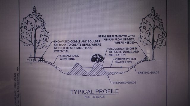
A graphic from Town application submitted by consultant CHA to state agencies. Royal Examiner Photos by Roger Bianchini
The concern expressed to Royal Examiner by interested citizens was how “clearcutting” shrubs and small trees from a creek bank contribute to stabilizing that bank? It would certainly seem counter-intuitive that clearing established vegetation from Happy Creek’s banks would stabilize those banks.
While awaiting a call back from Boyer we gave Interim Town Manager Matt Tederick a try as 5 o’clock approached. After leaving a message we heard back from Tederick after business hours late Thursday afternoon. Tederick explained Boyer had been in meetings with him much of the afternoon. Tederick confirmed that Public Works was doing the Happy Creek stabilization and stormwater management project and urged patience from citizens alarmed by the initial appearance of the creek bank in the early stages of the project. He reiterated the plan not to remove trees with a trunk circumference greater than 4 inches and disputed the term “clearcutting” being applied to the work.
|
“I understand the sentiment,” Tederick said of citizen concern over the project’s initial appearance. “But we got a DEQ Consent Order and obtained all the same permits and are following the same procedures we did on Eighth Street near Bing Crosby Stadium. We were asked to extend the work on Happy Creek to South Street. People are seeing the initial stage – it’s not clearcutting.”
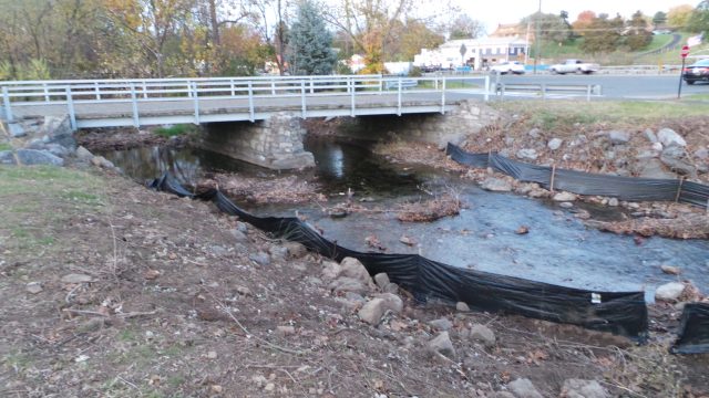
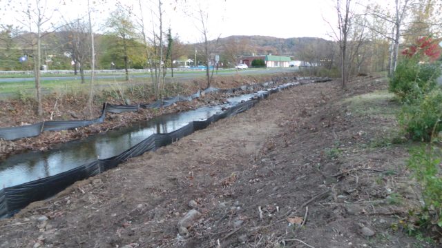
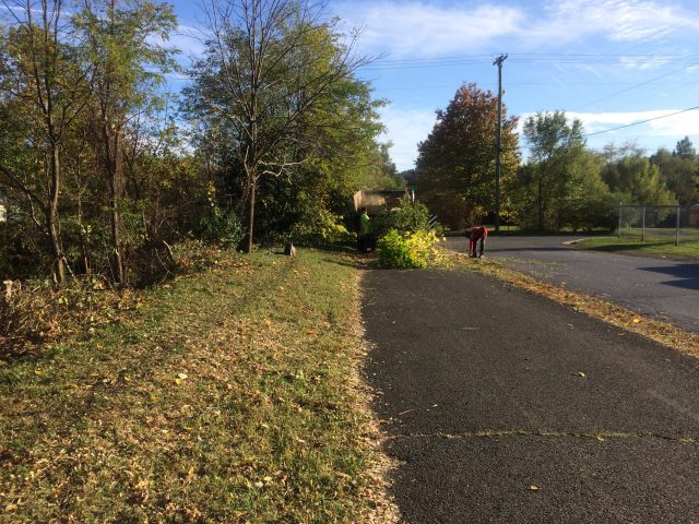
Above, looking northeast on Nov. 5 from the Front St. side of Happy Creek toward the Prospect St. Bridge and Commerce Ave.; below, the view south from the same spot. No replanting of removed vegetation is planned and large rocks will replace that vegetation as part of a stormwater management plan.
But in addition to clearing fallen trees and other debris out of the creek bed, vegetation is being cleared above the water level to be replaced by “rip-rap” or large stones that will help address past flooding issues on East Main and Water Streets near the creek to the north of Prospect Street – “It will be beautiful,” Tederick assured us, though adding that no replanting was planned where vegetation has been removed.
A divergent opinion
Royal Examiner also spoke with someone we know to have expertise in such matters, local Tree Steward official, past Town Urban Forestry Commission member, and Urban Forester/Environmental Scientist David Means. Means was aware of the work and expressed the opinion that what was being done along Happy Creek’s banks in town did appear contrary to established creek or riverbank stabilization principals.
He cited recommendations from the Virginia Department of Wildlife Resources’ regarding riparian buffers, stating, “We recommend avoidance of (removing) as much established native vegetation, including trees, as possible as they provide streambank stabilization, stream shading, and leaf litter which are important aspects of aquatic habitat.”
Means also said that measurements taken at the work site indicated stumps from more than 100 trees exceeding a diameter of four inches. – “Trees up to 13 inches in diameter have been cut down, exposing the greenway to the noise and views of busy Commerce Avenue,” Means asserted, adding, “These include trees donated by individuals and organizations to commemorate Arbor Day and enabling the Town to qualify for ‘Tree City USA’ status.
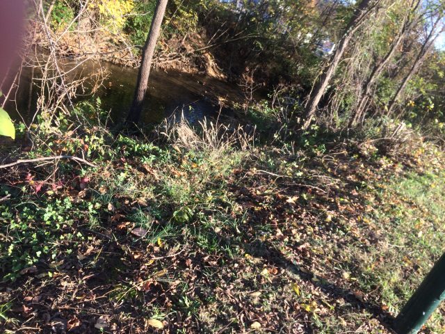
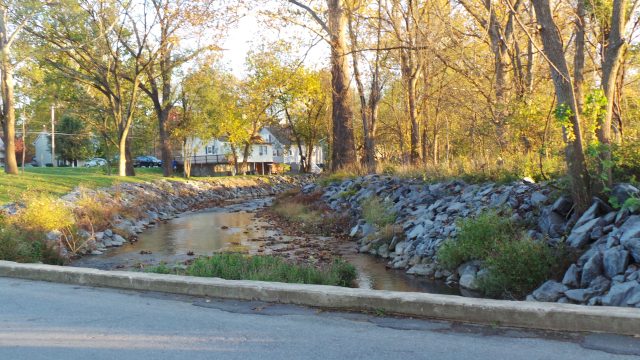
Above, part of the bank in question prior to the mid-October start of flood management work. Below, picking up trees and brush after clearing work began in mid-October. Courtesy Photos Tree Stewards
Of earlier Town work on the creek Means observed, “Between 2007 and 2010, the Town received two state grants to meet these specifications, one for installation of rock structures to reduce the velocity of the water, limit erosion, and create trout habitat. Native trees and shrubs were planted as well to create the shade and cool waters required by trout. The second grant, from the Department of Forestry, underwrote removal of invasive species from the riparian buffer zone.”
As for the current work, Means said he reviewed the Town’s permits and application materials, finding several deficiencies. “The application lacked a site-specific erosion and sediment control plan, specifications for the proposed work, a tree preservation plan, and restoration plan. All the application says is that the work will be done, with no specifics on materials, or method of installation – the detail is missing. The permit addresses ‘Happy Creek Streambank and Channel Restoration’ but work in progress is geared toward stormwater management and flood control, in which case the plan should have included an engineer’s calculations based on two-and 10-year storm events, upstream impervious surfaces, flow and velocity calculations supporting the intended design.”
Recommendations from the Virginia Department of Wildlife Resources regarding riparian buffers appear to be ignored in the Town’s work and plans, most pointedly, “restoring original streambed and streambank contours, revegetating barren areas with native vegetation, and implementing strict erosion and sediment control measures. We recommend that instream work be designed and performed in a manner that minimizes impacts upon natural streamflow and movement of resident aquatic species … To minimize harm to the aquatic environment and its residents … We (VDWR) recommend adherence to erosion and sediment controls during ground disturbance. We recommend use of native species for all plantings. We recommend alternatives to the creation of a hardened shoreline as such areas can prohibit access to aquatic habitats along stream margins” (emphasis added)”.
However, by the interim town manager’s own admission, there is no planned replanting and a “hardened shoreline” is exactly the intended endgame.
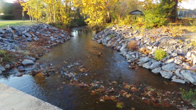
Above, the view north, and below, south at result of previous work at Eighth St. Bridge along Happy Creek’s bank. There is dispute that this end result is what the Town has been permitted for by state agencies between Prospect St. and South St. along the Greenway path.
In providing rationale for the work, Tederick referenced flooding in the Water-East Main Street area in the late 1990s. Means believes the proposed design would possibly exacerbate flooding problems, increasing velocity and volume to impact property downstream, particularly at the creek’s intersection with East Main, Stonewall, and Prospect Streets. Noting more recent federal moves prohibiting most floodplain construction, Means questioned the wisdom of past permitting in the creek’s floodplain on Water Street and nearby.
Means held a Virginia Erosion and Sediment Control Inspectors Certificate for nine years while employed by a design/build engineering company in Northern Virginia. Based on his observations of Happy Creek’s banks over a period of years, “Prior to this project, the banks appeared to be naturally stable, due to vegetation that actually reduced velocity and associated streambank erosion,” he reasoned.
Growing concern
On Friday, November 6, the Tree Stewards met with several interested parties to discuss concerns with the work. Invitees included the Urban Forestry Advisory Commission, Beautification of Front Royal Committee, Shenandoah Valley Alliance, and Appalachian Trail Community network. A joint letter of concern will be submitted to the Town, Means indicated.|
On the same day, Means met by phone with County Board of Supervisors Chairman Walt Mabe, who reported that County Building Official David Beahm had “shut the project down last Thursday, October 29.” However, Means documented crews continuing to cut trees down as recently as Wednesday, November 3.
According to Tederick, work began in mid-October, apparently between October 19 and 22. Contacted Friday, Tederick said he was unaware of any Stop Order on the project. He said that Beahm had contacted the Town regarding submission of an Erosion and Sediment Control Plan, which the town manager said had been submitted, and that work was continuing as planned.
We were unable to contact Beahm prior to the end of the workweek. Royal Examiner will continue to follow this developing story.

Cannabis Testing Challenges Persist as Virginia Retail Market Nears

Quick Quiz on Tooth Decay

The Fat Facts: Busting Common Food Myths

Importance of Chiles v. Salazar and the Protection of Free Speech

MAGA Suicide?

Warnick Posts Natural Hat Trick as Shenandoah Downs Opens Spring Meet

Youngkin Returns to Campaign Trail, Calls for Court to Strike Redistricting Vote

‘We Have To Do Something’: Former U.S. Attorney General Eric Holder Supports Virginia Redistricting

3 Ways to Extend the Life of Your Electric Vehicle Battery

Serious Charges Highlight Warren County Grand Jury Indictments

Ducks, Flowers, and Fun: Redbud Festival Returns to Browntown

Potato-Crust Quiche Makes a Lovely Brunch

Faye Barr Vance (1930 – 2026)

James Christopher “Chris” Sain (1948 – 2026)
Alice “Maybelle” Henson (1938 – 2026)

How Sleep and Stress Affect Cancer Risk

Spanberger Signs Sweeping Public Safety and Gun Violence Bills

Horses, Fans Return as Shenandoah Downs Season Begins

Skill Games Halted Again as Spanberger Issues Veto

VDOT: Warren County Traffic Alert for April 13 – 17, 2026

The Cat Who Outlasted Six Prime Ministers
Front Royal, Virginia. Vacation Destination?

Virginia State Police Report Major Drug Seizures in Weekly Crime Suppression Effort

Virginia Secures Birth Control Access as Other Southern States Eye Abortion Pill Manufacturers
