Local News
National Weather Services issues a winter weather advisory
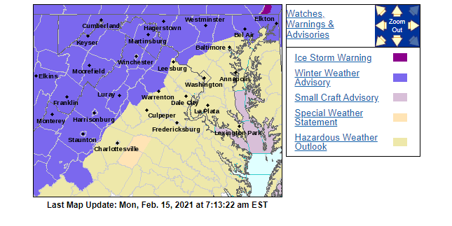
Winter weather advisory remains in effect until 7 am Tuesday
* WHAT…Light mixed precipitation today, with primarily freezing rain tonight. Little to no snow and sleet accumulation. Ice accumulations of one-tenth to one-quarter of an inch, the highest on the ridges.
* WHERE…Portions of western Maryland and eastern West Virginia, and Frederick County Virginia.
* WHEN…Until 7 AM EST Tuesday.

* IMPACTS…Difficult travel conditions and scattered tree damage are possible.
PRECAUTIONARY/PREPAREDNESS ACTIONS…
Slow down and use caution while traveling.
When venturing outside, watch your first few steps taken on
steps, sidewalks, and driveways, which could be icy and slippery,
increasing your risk of a fall and injury.

This Hazardous Weather Outlook is for portions of eastern West Virginia, northern and central Virginia, and central and western Maryland.
.DAY ONE…Today and Tonight
A Winter Weather Advisory is in effect through tonight for portions of western Maryland, eastern West Virginia, and Frederick County Virginia. Additional Winter Weather Advisories are in effect for the I-81 corridor and northern Maryland until 10 AM, then again from 5 PM until 7 AM.
.DAYS TWO THROUGH SEVEN…Tuesday through Sunday

There is an enhanced winter storm threat late Wednesday night into Friday morning. There is increased potential of more significant travel impacts and closures.
FORECAST
Washington’s Birthday
A chance of freezing rain before 10 am, then a chance of freezing rain and sleet between 10 am and 11 am, then rain likely after 11 am. Cloudy, with a high near 34. Calm wind becoming east around 5 mph in the afternoon. The chance of precipitation is 60%. Little or no ice accumulation expected. Little or no sleet accumulation expected.

Rain or freezing rain, becoming all rain after 11 pm. Patchy fog between 8 pm and 10 pm. Patchy freezing fog between 10 pm and 11 pm. Low around 32. East wind 5 to 7 mph becoming calm after midnight. The chance of precipitation is 100%. New ice accumulation of less than 0.1 of an inch possible.
A slight chance of freezing rain and sleet before 7 am, then a slight chance of sleet between 7 am and 8 am. Patchy fog before 8 am. Patchy freezing fog before 7 am. Otherwise, cloudy, then gradually becoming mostly sunny, with a high near 45. Light southwest wind becoming northwest 10 to 15 mph in the morning. Winds could gust as high as 23 mph. The chance of precipitation is 20%.
Partly cloudy, with a low around 20. Northwest wind 7 to 10 mph.
Partly sunny, with a high near 34. Northwest wind 5 to 8 mph becoming light and variable.

Snow, mainly after 1 am. Low around 25. The chance of precipitation is 80%.
Snow and freezing rain, possibly mixed with sleet before 2 pm, then freezing rain and sleet. High near 33. The chance of precipitation is 100%.
Freezing rain and sleet before 9 pm, then freezing rain between 9 pm and midnight, then rain after midnight. Low around 30. The chance of precipitation is 90%.
A chance of rain and snow before 11 am, then a chance of rain between 11 am and 5 pm, then a chance of rain and snow after 5 pm. Partly sunny, with a high near 40. The chance of precipitation is 40%.
A chance of snow before 7 pm. Partly cloudy, with a low around 20. The chance of precipitation is 30%.
Mostly sunny, with a high near 33.
Mostly clear, with a low around 16.
Mostly sunny, with a high near 41.


Screen Rules That Actually Work

Blue Ridge Wildlife Center Patient of the Week: American Barn Owl

After Taking Off in Charlottesville, Feds Plan National Electric Aircraft Charging Network Rollout

POLICE: 7 Day FRPD Arrest Report 7/20/2026

FDA: Taylor Farms iceberg lettuce sample produced a false positive for cyclospora

Data Centers Want to Build Their Own Gas Turbines. Would That Skirt State Renewable Energy Laws?

Legal Notice: Virginia Alcoholic Beverage Control (ABC) Authority

Removing a Senator

The Dillon Rule Doesn’t Say What Mr. Cuddeback Implies

Test Your Balance Before the Job Tests It for You
Legal Notice: Virginia Alcoholic Beverage Control (ABC) Authority

Late On Rent? New Virginia Law Gives Tenants More Time and Protection From Eviction

Virginia Schools Gain Spending Flexibility Under Federal Program

Three Useful Car Gadgets for a Better Summer Road Trip

When He Retires, Who Runs the Kitchen?

State of the Assistants: The Second Great Voice-Assistant War

Front Royal Family Practice Files $5-Million Civil Claim Against Valley Health and Warren Memorial Hospital

Virginia Violent Crime Fell Nearly 6% in 2025, State Police Report Shows

Virginia State Police Seize More Than $3.3 Million in Drugs During Weekly Operations

30-Acre ITFederal Property at Avtex Scheduled for Auction to Help Resolve EDA ‘Financial Scandal’ Debt to First Bank & Trust

Grand Jury Returns Dozens of Indictments in Warren County

VDOT: Warren County Traffic Alert for July 20 – 24, 2026

Fauquier Health CEO Earns National Recognition for Second Straight Year

Trail Option Draws Strongest Support in VDOT Shenandoah Rail Corridor Survey