State News
What is an Atlantic Niña? How La Niña’s Smaller Cousin Could Affect Hurricane Season
The North Atlantic Ocean has been running a fever for months, with surface temperatures at or near record highs. But cooling along the equator in both the Atlantic and eastern Pacific may finally be starting to bring some relief, particularly for vulnerable coral reef ecosystems.
This cooling comes from two climate phenomena with similar names: La Niña, which forms in the tropical Pacific, and the less well-known Atlantic Niña.
Both can affect the Atlantic hurricane season. While La Niña tends to bring conditions ideal for Atlantic hurricanes, the less powerful Atlantic Niña has the potential to reduce some of the hurricane risk.
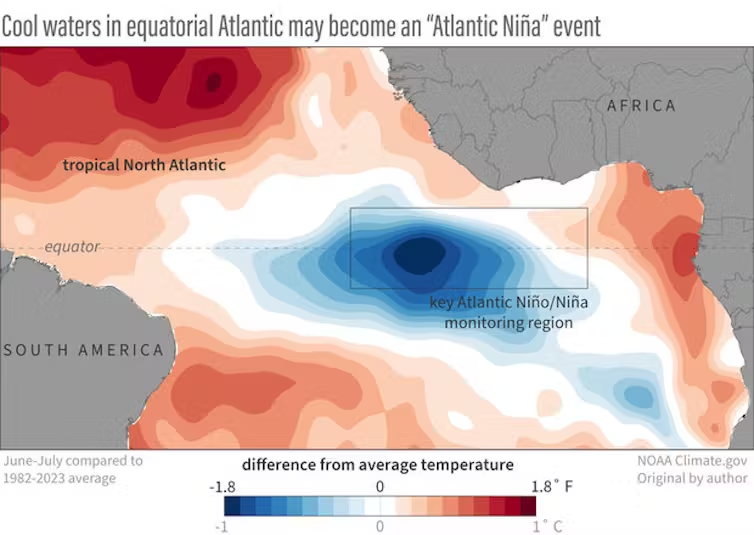
Cooling in the tropical Atlantic along the equator is a sign an Atlantic Niña may be forming. NOAA Climate.gov

We’re ocean and atmospheric scientists who study this type of climate phenomenon. It’s rare to see both Niñas at the same time, yet in August 2024, both appeared to be developing. Let’s take a closer look at what that means.
La Niña and its cousin, Atlantic Niña
La Niña is part of the El Niño–Southern Oscillation, a well-known climate phenomenon that has widespread effects on climate and weather around the world.
During La Niña, sea surface temperatures in the tropical Pacific dip below normal. Easterly trade winds then strengthen, allowing more cool water to well up along the equator off South America. That cooling affects the atmosphere in ways that reverberate across the planet. Some areas become stormier and others drier during La Niña, and the wind shear that can tear apart Atlantic hurricanes tends to weaken.
La Niña and its warmer opposite, El Niño, oscillate every three to four years or so.

A similar climate phenomenon, Atlantic Niña, occurs in the Atlantic Ocean but at a much smaller scale and amplitude. It typically peaks around July or August and tends to have a shorter duration than its Pacific cousin, and much more modest and local impacts. Atlantic Niñas generally have the opposite effect of Atlantic Niños, which tend to reduce rainfall over Africa’s Sahel region and increase rainfall in Brazil and the countries that surround the Gulf of Guinea, such as Ghana, Nigeria and Cameroon.
While much weaker than their Pacific counterpart, Atlantic Niñas can, however, partially counteract La Niñas by weakening summer winds that help drive the upwelling that cools the eastern Pacific.
Why are both happening now?
In July and August 2024, meteorologists noted cooling that appeared to be the development of an Atlantic Niña along the equator. The winds at the ocean surface had been weak through most of the summer, and sea surface temperatures there were quite warm until early June, so signs of an Atlantic Niña emerging were a surprise.
At the same time, waters along the equator in the eastern Pacific were also cooling, with La Niña conditions expected there by October or November.

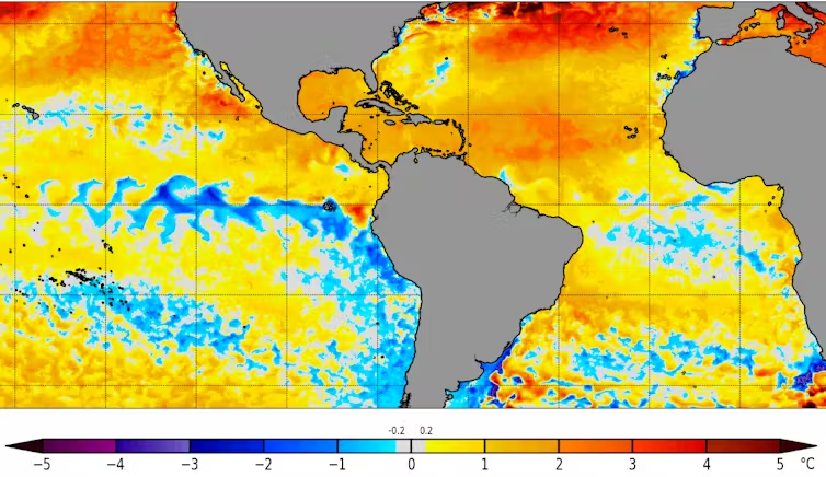
A map of sea surface temperature anomalies shows cooling along the tropical Atlantic and eastern Pacific regions, but much warmer than average temperatures in the Caribbean. NOAA Coral Reef Watch
Getting a Pacific-Atlantic Niña combination is rare but not impossible. It’s like finding two different pendulums that are weakly coupled to swing in opposite directions moving together in time. The combinations of La Niña and Atlantic Niño, or El Niño and Atlantic Niña are more common.
Good news or bad for hurricane season?
An Atlantic Niña may initially suggest good news for those living in hurricane-prone areas.
Cooler than average waters off the coast of Africa can suppress the formation of African easterly waves. These are clusters of thunderstorm activity that can form into tropical disturbances and eventually tropical storms or hurricanes.

Tropical storms draw energy from the process of evaporating water associated with warm sea surface temperatures. So, cooling in the tropical Atlantic could weaken this process. That would leave less energy for the thunderstorms, which would reduce the probability of a tropical cyclone forming.
However, NOAA takes all factors into account when it updates its Atlantic hurricane season outlook, released in early August, and it still anticipates an extremely active 2024 season. Tropical storm season typically peaks in early to mid-September.
Two reasons are behind the busy forecast: The near record-breaking warm sea surface temperatures in much of the North Atlantic can strengthen hurricanes. And the expected development of a La Niña in the Pacific tends to weaken wind shear – the change in wind speed with height that can tear apart hurricanes. La Niña’s much stronger effects can override any impacts associated with the Atlantic Niña.
Exacerbating the problem: Global warming
The past two years have seen exceptionally high ocean temperatures in the Atlantic and around much of the world’s oceans. The two Niñas are likely to contribute some cooling relief for certain regions, but it may not last long.

In addition to these cycles, the global warming trend caused by rising greenhouse gas emissions is raising the baseline temperatures and can fuel major hurricanes.
by Annalisa Bracco, Virginia Mercury
Virginia Mercury is part of States Newsroom, a nonprofit news network supported by grants and a coalition of donors as a 501c(3) public charity. Virginia Mercury maintains editorial independence. Contact Editor Samantha Willis for questions: info@virginiamercury.com. Follow Virginia Mercury on Facebook and X.


Fair Estate Planning Can Help Prevent Family Disputes

Chelsea Academy Announces Summer Sports, Academic, and Activity Camps

VA250 Mobile Museum Experience Coming to Front Royal June 18-21

Trump Touts Farm Policies, Trade, and Rural Priorities During Wisconsin Visit

US Senate Blocks Trump’s SAVE America Act, Thwarting Restrictions on Voting

The Ocean Is Fighting Back

Simple Ways to Personalize a Father’s Day Card

Careful Planning Helps Keep Livestock Safe During Transport

The People’s Power Begins with the Ballot

Front Royal Cardinals Host Woodstock River Bandits, Sunday – June 7

New Economic Development Director Shares Modus Operandi At Joint Town Council and Board of Supervisors Work Session

Topography Complicates Automobile Graveyard Application at Town Planning Commission Work Session

VDOT: Warren County Traffic Alert for June 8 – 12, 2026

Virginia State Police Report Firearms, Narcotics Seizures in Weekly Crime Suppression Operations

Warren County APS Urges Residents to Watch for Elder Abuse, Financial Scams

Business Growth Series: No Clear Goal? No Growth.

After Ashland Dam Removal, Freshwater Mussel Species Reintroduced to South Anna River

Commentary: What Virginians’ and Americans’ D-Day Sacrifices Teach Us About Our Country Now

FOIA Friday: Richmond City and Schools Face Scrutiny

Johnnie Otis Kaufman Jr. (1946 – 2026)

Patio Season Brings an Easygoing Taste of Summer

Humane Steps Can Help Protect Gardens from Local Wildlife
Front Royal Cardinals Host Winchester Royals Saturday – June 6

Edward “Henley” Brown Sr. (1940 – 2026)
